


Flomaton Town Hall, Escambia County, Alabama
About
Outline

Summary
| Unique Area Identifier | 521735 |
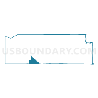
| Name | Flomaton Town Hall |
| County | Escambia County |
| State | Alabama |
| Area (square miles) | 14.66 |
| Land Area (square miles) | 14.44 |
| Water Area (square miles) | 0.22 |
| % of Land Area | 98.52 |
| % of Water Area | 1.48 |
| Latitude of the Internal Point | 31.01752310 |
| Longtitude of the Internal Point | -87.31865390 |
Maps

Graphs
Select a template below for downloading or customizing gragh for Flomaton Town Hall, Escambia County, Alabama


Neighbors
Neighoring Voting District (by Name) Neighboring Voting District on the Map
- 514-Voting District, Escambia County, FL
- 516-Voting District, Escambia County, FL
- Canoe- Civic Club, Escambia County, AL
- Flomaton Community House, Escambia County, AL
- Little Escambia, Escambia County, AL
- Little Rock Store, Escambia County, AL
Top 10 Neighboring County Subdivision (by Population) Neighboring County Subdivision on the Map
- Atmore CCD, Escambia County, AL (12,372)
- Century CCD, Escambia County, FL (9,859)
- Flomaton CCD, Escambia County, AL (3,632)
Top 10 Neighboring Place (by Population) Neighboring Place on the Map
Top 10 Neighboring Unified School District (by Population) Neighboring Unified School District on the Map
Top 10 Neighboring State Legislative District Lower Chamber (by Population) Neighboring State Legislative District Lower Chamber on the Map
Top 10 Neighboring State Legislative District Upper Chamber (by Population) Neighboring State Legislative District Upper Chamber on the Map
Top 10 Neighboring 111th Congressional District (by Population) Neighboring 111th Congressional District on the Map
Top 10 Neighboring Census Tract (by Population) Neighboring Census Tract on the Map
- Census Tract 39, Escambia County, FL (5,068)
- Census Tract 40, Escambia County, FL (4,791)
- Census Tract 9706, Escambia County, AL (4,035)
- Census Tract 9703, Escambia County, AL (3,632)
- Census Tract 9707, Escambia County, AL (3,518)